
Decision Environment Examples
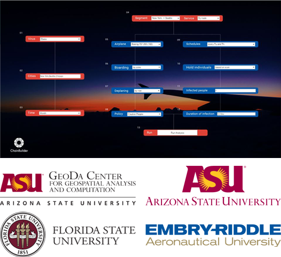
VIPRA (Viral Infection Propagation Through Air-Travel)
Challenge: To analyze new strategies for reducing the risk of spread of Viral infections through air-travel using a computational infrastructure. The system must determine a range of possible outcome scenarios, identify possible vulnerabilities, and evaluate the relative merits of feasible policy choices.
Results: The Chainbuilder team has worked closely with others at Arizona State University, Florida State University, and Embry-Riddle Aeronautical University to develop the a fine-scale model that tracks individual passenger movement in airplanes, based on social dynamics and empirically observed passenger behavioral characteristics. Sources of uncertainty are parameterized, and simulations performed to cover the range of uncertainties. Results from individual flights are linked with genetic information in a phylo-geographic model in order to evaluate the likelihood of epidemics and to identify pathways for the spread of diseases. The analysis is also validated with empirical data in order to ensure that guidance offered by this analysis is likely to be realistic. The model will help achieve VIPRA’s goal of deploying a comprehensive and accurate decision-support infrastructure that can be used eliminate the threat of any new outbreak of an epidemic.
More information on this project can be found here: http://www.cs.fsu.edu/vipra/
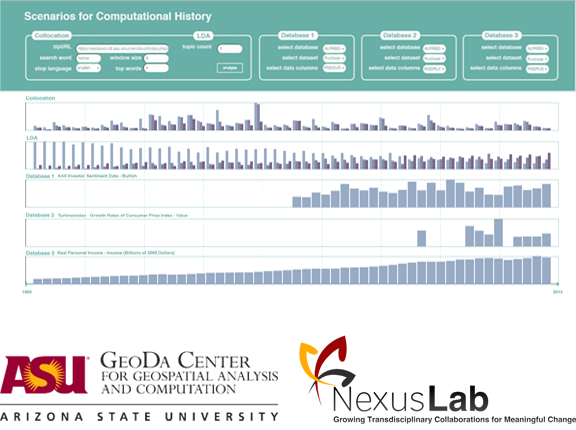
SCH (Scenarios for Computational History)
Challenge: To develop a complex modeling system for humanists—historians, cultural theorists, literary critics, anthropologists, etc. that will address topics often at the heart of their disciplines: the complex interrelationship among persons and things, human culture and so-called “nature”, and the activity and impact of health, embodiment, and care. This is a departure from the traditional idea that complex modeling systems are only beneficial for scientists, policy makers, and engineers.
Results: Chainbuilder is creating a complex modeling system that responds to two major challenges: 1) how do we responsibly model humanistic insights for the purposes of modeling, inference, and prediction? 2) in the event that mathematically modeling humanistic analysis and evidenciary procedures is unacceptable, how do we present and use a historical or cultural analysis alongside statistics in a multi-display environment that does more than simple juxtaposition, where layout is not a substitute for integrative analysis?
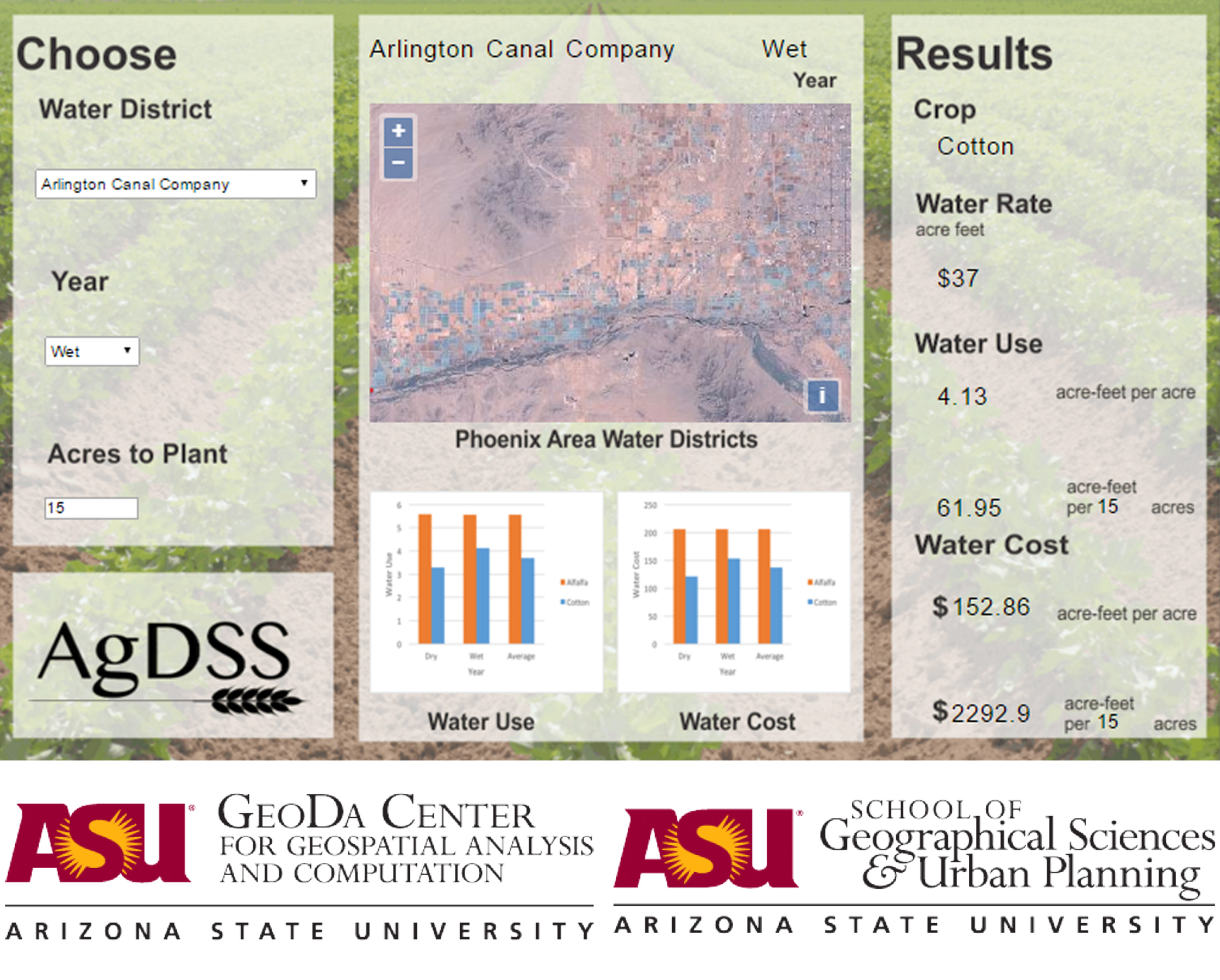
AgDSS (Agriculture Decision Support System)
Challenge: Integrate Evapotranspiration data with local water costs to develop a decision support system for Arizona farmers and water resource managers. Users will be able to determine which agricultural crops use the least amount of water and cost the least in each water district in Maricopa County Arizona.
Results: Chainbuilder provides the platform for the Agriculture Decision Support System (AgDSS). Results of a Water Use Optimization Model model run the background of the system. The objective of this model is to determine which crop in each district has the minimum water use and costs. This optimization model calculated, in acre feet the, the water use for every crop in each district then determined which crops use the least water in each district. The cost of that water based on the water use and the district water rates was also calculated. The Chainbuilder platform also provides the user-interface for AgDSS. In the user-interface the user can choose a water district, the type of water year (dry, wet, or average), and the amount of acres to plant. The user-interface then displays the results of the optimization model.

ACUTE (Advanced Cancer Unified Treatment Environment)
Challenge: Revolutionize the medical approach to the diagnosis and treatment of breast cancer. While current tumor boards are able to relay static data from medical charts, they lack interactivity between patients, their doctors, different specialists, patient advocates, and all other stakeholders.
Results: ChainBuilder is used to visualize the interdependence of a patient’s many treatment components in real-time.The ACUTE decision support system will aids the treatment decisions made by cancer tumor boards, by providing interactive features, visual displays, and a database of treatment options. This multi-level system will allow doctors to input patient data, diagnostic images and information through tablet applications, as well as import medical history and Electronic Medical Records. This information feeds into the ChainBuilder and a multi-screened decision environment for use in the tumor board setting. Patient information will automatically generate a selection of customized treatment options for that patient, as well as information on the success and side effects of those treatments, allowing doctors to make better decisions about patient care.
Features of the ACUTE system include visual display and background information on the genetic profile of the patient, radiology and pathology reports, and a dynamic timeline visualizations of patient health and treatment success. Multiple monitors are used to display these features and generate intuitive, effective visual aids, allowing doctors and other medical professionals to collaboratively work to improve patient care.
CyberGIS Software Integration for Sustained Geospatial Innovation
Challenge: Seamlessly integrate cyberinfrastructure, GIS, and spatial analysis/modeling capabilities into a fundamentally new software framework for CyberGIS.
Results: The project (1) engages a multidisciplinary community through a participatory approach in evolving CyberGIS software requirements; (2) integrates and sustains a core set of CyberGIS software elements based on community-driven and open source strategies; (3) empowers high-performance and scalable CyberGIS by exploiting spatial characteristics of data and analytical operations; (4) enhances an online geospatial problem solving environment to allow for the contribution, sharing, and learning of CyberGIS software by numerous users; (5) deploys and tests CyberGIS software by linking with national and international cyberinfrastructure; and (6) evaluates and improves the CyberGIS framework through domain science applications to gain better understanding of the complexity of coupled human-natural systems. The project's principal investigator is Dr. Luc Anselin, Regent's Professor and Walter Isard chair in ASU's School of Geographical Sciences and Urban Planning and Director of the GeoDa Center for Geospatial Analysis and Computation. The project's co-principal investigator is Dr. Sergio Rey, professor in ASU's School of Geographical Sciences and Urban Planning.
This is an ongoing project for which updated information can be found here: cybergis.cigi.uiuc.edu
AZ SMART (Arizona Solar Market Analysis Research Tool)
Challenge: Users must be able to analyze and determine the best possible means to provide power to the state of Arizona. Furthermore, users must be able to make informed decisions based on the power benefit versus the economic and environmental cost of any type of power installation, including coal-fired or solar-panel plants. The decision environment must also take into account how current power lines and line capacities influence power distribution.
Results: ChainBuilder provides the computational structure for an enterprise ready decision environment that consists of seven screens. The multi-level system allows users to input key variables such as power station location and type. It also allows users to analyze the impact of power generation. The environment generates a cost-benefit analysis of financial cost and environmental impact for each potential power station. Once a user has selected a location and type for a new power generating station, the system automatically maps, calculates, and displays the expected costs, environmental impact, amount of new power generated, and the locations that new power will be able to reach. This allows the decision-maker to view the overall impact of potential power generating stations, easily compare and contrast options, and finalize decisions in a completely informed manner.

Flexible Geospatial Visual Analytics and Simulation Technologies to Enhance Criminal Justice Decision Support Systems
Challenge: Combine statistical and geographical data in order to create an enhanced decision support system for criminal justice interventions. Users should be able to analyze the locations and densities of crimes in order to better understand what is needed to create law enforcement plans.
Results: The challenge was met with a flexible methodological framework that integrates geospatial visual analytics and spatial econometrics with state-of-the-art geocomputation. The system provides key information about the prevalence of crimes and the areas in which they occur. The system has been fully realized in an open source and cross-platform modular software toolbox delivered through a multitude of user interfaces, including traditional free-standing desktop software, toolbox extensions to commercial GIS, Web services, and integration into the ChainBuilder environment.
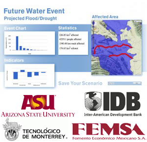
Water Innovation Consortium
Challenge: The InterAmerica Development Bank (IDB) water management pilot project was designed to address upcoming issues with water management and flooding in Monterrey, Mexico. The goal was to integrate watershed observation, modeling, decision-maker engagement and decision-support system development to support decision-makers and community stakeholders of the San Juan River Basin (SJRB) in their efforts to utilize both existing and future water resources effectively and sustainably.
Results: An integrated approach with elements that include existing information, ongoing watershed assessment, interactive simulations, decision-maker engagement and decision capacity building was developed. The decision environment prototype created allows the user to select scenarios for future changes in water supply, population growth, climate change, and disaster events like flooding. The user is then able to select from a variety of potential solutions, such as reforestation of barren areas or building dams, and compare the effectiveness and these solutions according to various metrics. The results and impact of these solutions are then automatically calculated, and, across this seven screen decision environment, graphs, maps, imaging, and text are automatically updated. A decision-maker can then compare the cost, affected area, success rate, and other features of a chosen solution under different projected future scenarios.
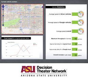
Google Cars Project
Challenge: The Google Cars Project is responsible for a new, innovative line of self-driving cars. Because of it's innovative nature, the Cars Project requested a system that could easily quantify the potential value it offers to commercial, delivery-based companies. The Cars Project required a a comprehensive system to compare the cost and safety features of Google’s self-driving cars in comparison to ordinary cars.
Results: An informative program was designed to illustrate the cost-benefits a self-driving car. The system accurately displays the various challenges that delivery systems face. It then computes the changes in risk between a conventional and a Google Car. ChainBuilder computes specific queries. It also takes into account automotive responses to weather, other drivers, traffic, gas usage, emergencies, and dangers ahead.
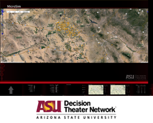
PODS (Points of Dispensement)
Challenge: Due to various restraints, is difficult to provide students in Emergency Response programs with real world experience. As a result, it was requested that computer simulations be designed. Students must be able to experience the micro and macro effects of their crisis management decisions. More specifically, the simulation should visualize possible emergency response plans in the event that toxins or biochemicals are released. The results of the simulation should apply to actual, populated areas.
Results: ChainBuilder was integrated into a program that works on two levels. First, Emergency Response trainees can view a geographical area on a macro-level. As a simulated toxic disaster unfolds, trainees must use their skills to identify which treatment centers they will or will not open. On a micro-level, trainees manage individual centers. They must design the intake, treatment, and discharge process. They must input points of dispension and other important factors. PODS takes into account time limitations, collaboration, etc. PODS allows trainees to develop experience through virtual trial & error. It also provides guidance by allowing trainees to view optimal solutions generated by the computer. In the event of a real disaster, Emergency Responders should be prepared to fully utilize their resources, including traffic and economics.
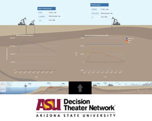
PEMEX (Petróleos Mexicanos)
Challenge: The goal is a web-based model that can be used to explore the new energy sector of Mexico. New investments have been made in the Hydrocarbon Energy Sector across various subsectors including Fractured deposits, Non-Fractured deposits, Shale, Deep Water, Refineries among others. Those new investments call for a better understanding of how to manage sectors in an optimal way.
Results: PEMEX coordinates efforts between various parties such as SENER (Ministry of Energy), foreign investors, PEMEX, national investors, Federal Electricity Commission and Hacienda (Treasury) in a highly visual and immersive environment. Such an environment allows decision makers to optimize investments and identify areas for improvement.
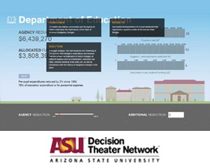
AZ Budget
Challenge: "To enable law makers, economists and the layman to better understand the implications of the State of Arizona’s budgetary changes."
Results: "A Budget Analysis Tool that visualizes the modelling of the Arizona State Budget’s expenditure and revenue. The tool shows the implication of minor changes on different aspects such as employment, education, tax rates, national standing of the state, etc. as well as comparison with the history of budgetary changes in the state." This led to the: "Successful implementation of a visual dashboard that represents a dynamic model of the Arizona State Budget."